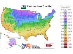
USDA Releases New Plant Hardiness Zone Map
January 27, 2012 | 1 min to read

A new Plant Hardiness Zone Map released by the federal government Wednesday shows that temperatures across the country are getting warmer and could affect gardens and crops.
The map is designed to help the estimated 80 million gardeners in this country, as well as farmers and horticulture businesses, identify where and when plants grow best by breaking up geographical areas into 26 zones.
It's the first time since 1990 that the U.S. Department of Agriculture has updated the map. The new one offers an interactive format and looks at 30 years of weather patterns, showing that in some cases – Ohio, Nebraska and Texas – nearly entire states have been updated to warmer zones. Even California's temperate climate has seen change, with a number of communities in the Bay Area also being shifted to warmer zones.
The USDA is attributing the zone modifications to better data and technology. The new map also takes into account topography – slope, elevation, prevailing winds and proximity to water – for the first time.
To read the rest of the story, please go to: San Francisco Chronicle
